
INTRODUCTION
Energy security has become a critical issue for many countries. Exploitation and exploration of offshore oil and gas resources plays the central role in the fast-changing global energy landscape. This pursuit of energy stability has significantly increased the importance of maritime zones, especially the Exclusive Economic Zones[1] (EEZs), where coastal states possess sovereign rights over natural resources. Coastal states seek to secure oil, gas, and fisheries within 200 nautical miles of their baselines, sometimes leading to overlapping jurisdiction. The establishment of EEZs has created over 430 potential maritime boundaries between States with opposite or adjacent coasts, more than half of which remain undelimited.[2] Indeed, the “incomplete nature of the maritime political map of the world” – with less than 40% of potential international maritime boundaries formally agreed as of the mid-2000s – creates “jurisdictional uncertainty” that can be “detrimental to maritime security”. In geographically constrained areas such as semi-enclosed seas, the 200-nautical-mile claims of neighbouring States inevitably overlap, creating zones of contested jurisdiction.[3] Without agreed boundaries, such situations risk conflict or stalemate, delaying energy projects and discouraging investment. Overlapping EEZ claims are a global problem,[4] and resolving them is crucial for both regional stability and efficient energy development. However, resolving these disputes through traditional boundary delimitation can be challenging therefore, states continuously are exploring alternative solutions.
This essay explores how overlapping EEZ claims can be resolved, especially in offshore energy contexts. Considering the legal framework under the United Nations Convention on the Law of the Sea (UNCLOS) and customary international law, it examines key causes of these disputes—from geography to politics—and outlines available resolution methods, including courts and arbitration. Case studies from the Black Sea, Eastern Mediterranean, and South China Sea illustrate how such conflicts occur in practice. The essay also considers interim solutions like joint development agreements and reflects on the broader challenges and future of managing maritime disputes.
I. LEGAL FRAMEWORK OF EXCLUSIVE ECONOMIC ZONES UNDER UNCLOS
The concept of the Exclusive Economic Zone is a creation of modern international law, the idea of which is codified in UNCLOS 1982.[5] Unlike the continental shelf, the coastal State must claim the zone in order to establish an EEZ. The vast majority of coastal States have claimed a 200-mile EEZ.[6] Seven leading beneficiaries of the EEZ are: the USA, France, Indonesia, New Zealand, Australia, Russia and Japan.[7]
- Definition and Scope of EEZ under UNCLOS
The EEZ is a maritime zone of a sui generis legal character, as it is neither extension of the territorial sea nor a part of the high seas, it is distinguished from both.[8] It is an area beyond and adjacent to the territorial sea, extending up to 200 nautical miles from the baselines, within which UNCLOS establishes a careful balance between the rights of the coastal State and those of other States.[9]
Article 56 of UNCLOS grants coastal states sovereign rights over natural resources in the EEZ.[10] These sovereign rights consist of exploration, exploitation, conservation and management of both living and non-living natural resources, making the EEZ particularly relevant for offshore energy development.[11] These are not rights of full sovereignty, as exist in the territorial sea,[12] but are functional rights limited to the economic purposes specified.[13] In this respect, the concept of sovereign rights must be distinguished from territorial sovereignty, which is comprehensive unless international law provides otherwise. In addition to these sovereign rights, the coastal State has jurisdiction in order to establish and use of artificial islands, marine scientific research, and the protection of the marine environment.[14]
On the other hand, Article 58 of UNCLOS protects certain international freedoms which apply to the high seas within the EEZ, including the rights of navigation, overflight, and the laying of pipelines and submarine cables by foreign countries.[15] The relationship between these two sets of rights is governed by the principle of ‘due regard’: Article 56(2) requires the coastal State, in exercising its rights, to have ‘due regard to the rights and duties of other States’; reciprocally, Article 58(3) requires other States to have ‘due regard to the rights and duties of the coastal State’.[16] This balance between coastal state rights and international freedoms reflects the compromise that made UNCLOS possible, but it also creates potential areas of conflict, particularly regarding the interpretation of sovereign rights versus jurisdictional competence.[17]
- Delimitation Principles under UNCLOS
The delimitation of the EEZ between states with opposite or adjacent coasts is governed by Article 74 of UNCLOS, which establishes the fundamental principle that delimitation “shall be effected by agreement on the basis of international law, as referred to in Article 38 of the Statute of the International Court of Justice, in order to achieve an equitable solution”.[18] This provision reflects the customary international law principle that maritime boundaries should be delimited through negotiation and agreement between the parties concerned.[19]
The reference to “international law” in Article 74 incorporates both treaty and customary international law principles. Achieving an ‘equitable solution’ is the main goal in any EEZ delimitation.[20] The equitable solution requirement does not require any specific delimitation method, letting states be flexible during negotiations. However, international jurisprudence has developed a three-stage methodology for maritime delimitation that has become widely accepted.[21] First, a provisional equidistance line is constructed using appropriate base points on the relevant coasts.[22] Second, this provisional line is examined to determine whether relevant circumstances require its adjustment to achieve an equitable result.[23] Third, the court or tribunal conducts a disproportionality test to ensure that the resulting boundary does not lead to an inequitable allocation of maritime areas.[24]
‘Relevant circumstances’ factors are unique to each case. While there is no exhaustive list, relevant circumstances are geographical in nature in majority, including the general configuration of the coasts, the presence of islands and their location, and significant disparities in the lengths of the relevant coastlines.[25]
- Customary International Law and EEZ Delimitation
The EEZ concept and the principles for EEZ delimitation under UNCLOS are recognized as a part of customary international law. This means that even states not party to UNCLOS can be bound by its fundamental principles. State practice has contributed to this customary status. By 1984, the International Court of Justice (ICJ) itself opined on the EEZ’s status in customary international law.[26] The principle of relevant circumstances often guides customary international law in delimitation. The 1958 Geneva Convention on the Continental Shelf, in its Article 6, established the ‘equidistance/special circumstances’ rule, which provided that in the absence of agreement, the boundary should be the median line unless special circumstances justified another boundary.[27] This approach was famously challenged in the 1969 North Sea Continental Shelf Cases.[28] ICJ held that the equidistance principle was not a mandatory rule of customary international law.[29] Instead, the Court emphasised that delimitation must be effected by agreement in accordance with ‘equitable principles’, taking all relevant circumstances into account, to ensure that each State receives the natural prolongation of its land territory without encroaching on that of its neighbour.[30] This judgment created a period where the law appeared to favour a flexible, principles-based approach over a rigid, method-based one.[31] The ICJ, for instance, has applied the above-mentioned three-stage process in delimitation cases. The “long usage” of economic interests related to specific regions can also be taken into account when applying customary international law under Article 7 of UNCLOS.[32]
II. CAUSES OF OVERLAPPING EEZ CLAIMS
The most fundamental cause of overlapping EEZ claims is the geographical proximity of coastal states. When states are opposite or adjacent to each other, their potential 200-nautical-mile EEZs naturally extend into the same maritime space and overlap. This is particular in semi-enclosed seas like the Mediterranean Sea or the Black Sea.[33] Beyond proximity, geomorphological features also play a critical role. For instance, a concave coastline can cause a strict equidistance line to swing inward, severely limiting the maritime space of the State with the concave coast—a phenomenon known as the ‘cut-off’ effect.[34] This is a classic example of a ‘relevant circumstance’ that international courts will consider to achieve an equitable result.[35] Historically, the geological principle of ‘natural prolongation’—the idea that a State’s continental shelf is the natural extension of its land territory under the sea—was a significant factor in continental shelf disputes.[36] The continental shelf, defined under Article 76 of UNCLOS, can extend beyond 200 nm, based on the natural prolongation of the land territory.[37] This creates a potential for overlapping entitlements between a state’s extended continental shelf and another state’s EEZ.
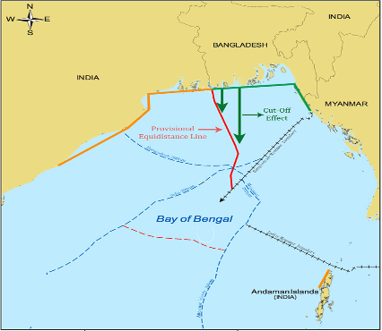
Figure 1.[38]
The sovereignty over islands and other maritime features significantly impacts the extent of EEZ claims. Article 121 of UNCLOS distinguishes between “islands” and “rocks”. Islands are entitled to their own territorial sea, contiguous zone, EEZ, and continental shelf, while “rocks which cannot sustain human habitation or economic life of their own shall have no exclusive economic zone or continental shelf”.[39] Disputes often arise over the classification as an island or a rock. For instance, in the Black Sea case, Ukraine argued that Serpents’ Island was an “island” under Article 121(2), implicitly including a “rock” under Article 121(3), which would grant it full maritime zones.[40] Unclear language of Article 121(3) makes things even more complicated. The South China Sea Arbitration struggled in applying Article 121(3) of UNCLOS and established that the determination of whether a feature can sustain human habitation or economic life of its own must be based on the natural capacity of the feature, excluding artificial modifications or external support.[41] This interpretation has significant implications for other maritime disputes involving small islands or artificial features.
States are making big maritime claims because they need more energy and have found big offshore oil and gas and renewable energy resources.[42] This phenomenon is clearly visible in the Eastern Mediterranean. While tensions between Greece and Türkiye over the Aegean Sea are long-standing, the discovery of major natural gas fields in the Levantine Sea after 2009 dramatically raised the stakes.[43] The energy resources did not cause the underlying legal disputes, but they sped long-running arguments into a serious regional crisis.
Although they are not explicitly recognized under UNCLOS, historic rights are still claimed by many states in areas beyond their EEZ. China’s “nine-dash line” claim in the South China Sea is a prominent example, asserting historic rights over fisheries resources within this line, despite being challenged by other states.[44] Geopolitical concerns can also influence a state’s approach to delimitation and resource sharing. For instance, Norway’s agreement with Iceland over the Jan Mayen area was influenced by overarching security concerns involving The North Atlantic Treaty Organization (NATO) powers and the strategic importance of the Keflavik military base.[45] This shows that national security and broader strategic interests can override purely economic considerations in reaching agreements.
III. DISPUTE SETTLEMENT MECHANISMS UNDER INTERNATIONAL LAW
Under UNCLOS, dispute resolution is governed by Part XV, which is divided into three sections.[46] Section 1 encourages states to settle their disputes peacefully through traditional means such as negotiation, conciliation, or other agreed approaches.[47] If countries have already agreed to settle a dispute about interpreting or applying UNCLOS through another method, then the procedures under Part XV do not apply (Articles 281 and 282).[48] States are also free to use peaceful means of their own choosing (Article 280), and they must first exchange views on how to resolve the matter before going to court or arbitration (Article 283).[49] If these efforts fail, Section 2 allows any party to bring the case to a tribunal, such as ITLOS, the ICJ,[50] or an arbitral panel under Annex VII or VIII. These compulsory proceedings (Article 286) lead to final, binding decisions (Article 296).[51] Article 287 lets states choose their preferred forum, and if no agreement exists, default rules decide the venue.[52] Courts also have the power to confirm their own jurisdiction (Article 288).[53] Additionally, Section 2 includes urgent procedures for situations like the prompt release of vessels (Article 292) and provisional measures (Article 290).[54]
Section 3 sets important limits on compulsory dispute settlement. It specifically confirms a number of issues in relation to which Section 2 is applicable and compulsory settlement procedures do apply, especially for sensitive issues like a coastal state’s control over fisheries in its EEZ, boundary delimitation, and military activity.[55] Article 297 narrows the scope of mandatory procedures for these areas but also makes clear that compulsory settlement still applies.[56] Article 298 allows states to opt out of binding procedures in certain cases by making a written declaration, including matters like maritime boundaries, military actions, or law enforcement.[57] These exceptions apply only if declared and operate on a reciprocal basis. However, even when a dispute falls under these exclusions, states can still choose to resolve it by mutual agreement.[58] UNCLOS tries to offer legal solutions to resolve disputes while respecting state sovereignty in areas of vital national interest.
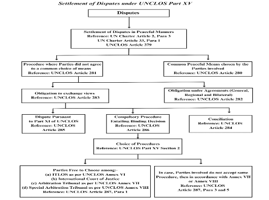
Figure 2:[59] The Dispute Resolution Approaches within UNCLOS.
IV. CASE STUDIES OF OVERLAPPING EEZ DISPUTES
- The Black Sea Case (Romania v Ukraine)
The Black Sea case between Romania and Ukraine is considered to be the best example of peaceful resolution of a maritime boundary dispute. The dispute arose when the two countries’ 200 nm EEZ/continental shelf claims intersected in the western Black Sea. The main point of disagreement was Snake Island (Serpents’ Island), located not far from the Danube Delta and controlled by Ukraine. If Snake Island were treated as a full-fledged island, Ukraine argued, it would generate its own maritime zones, pushing the boundary line significantly toward the Romanian coast.[60] Romania contended that Snake Island was a mere rock (incapable of sustaining habitation under UNCLOS Article 121(3)) and should be given no effect in drawing the boundary.[61] After protracted bilateral talks failed, Romania filed an application at the ICJ in 2004 pursuant to a compromise between the parties (Ukraine, though not having a general ICJ jurisdiction acceptance, agreed to the Court’s jurisdiction in this specific case by treaty). The Court followed a standard, three-stage delimitation methodology, first establishing a provisional equidistance line based on “methods that are geometrically objective” (para. 116), second considering “whether there are factors calling for the adjustment or shifting of the provisional equidistance line in order to achieve an equitable result” (para. 120), and third verifying that the provisional equidistance line, adjusted or not, does not “lead to an inequitable result by reason of any marked disproportion between the ratio of the respective coastal lengths and the ratio between the relevant maritime area of each State” (para. 122).[62] The Black Sea case is significant because it provided a clear, systematic, and authoritative application of the three-stage methodology and demonstrated that judicial settlement can provide solutions to a complex maritime dispute therefore create the legal foundation required for both States to proceed with offshore energy exploration in their respective maritime zones.[63]
- Eastern Mediterranean Disputes (Türkiye, Greece, Greek Administration of Southern Cyprus, others)
The Eastern Mediterranean cases are quite different from the Black Sea case – here, multiple overlapping EEZ claims remain unresolved, and significant offshore energy resources located. The dispute involves several states, including Türkiye, Greece, Greek Administration of Southern Cyprus, Egypt, Israel, and Lebanon, unlike the Black Sea dispute which was one-on-one,
One of the main disputes caused by Türkiye’s non-recognition of the Greek Administration of Southern Cyprus (GASC) and the related EEZ claims.[64] The GASC has set a nominal EEZ and signed nominal boundary agreements with Egypt, Israel, and Lebanon (though the Lebanon one is pending ratification).[65] Türkiye, however, does not recognize the GASC (due to the division of the island and its backing of the Turkish Republic of Northern Cyprus, or TRNC). Türkiye therefore claims that GASC has no authority to exploit resources unilaterally and Türkiye officials have repeatedly argued that the GASC’s offshore drilling is illegitimate. This means that Türkiye disputes the EEZ that GASC has declared around the island and has asserted parts of that area as falling within Türkiye’s own continental shelf.[66]
Another legal debate is the role of islands in delimitation, notably Megisti (Kastellorizo), a small Greek island. Greece’s position is that all its islands, without exception, generate the full maritime zones (EEZ/continental shelf) as per UNCLOS.[67] Türkiye, which is not a party to UNCLOS (partly due to these very issues), argues that in an enclosed sea like the Eastern Mediterranean, islands located on the “wrong side” of the median line between two main lands should not have full effect, especially if they are small and far from their own mainland.[68] Essentially, Türkiye believes that an equitable delimitation in the region should be between mainland coasts, with only enclaved zones for certain Greek islands that lie very close to Türkiye.[69] Türkiye often cites the ICJ’s statement in the North Sea Continental Shelf cases that no state should be cut off from the sea by another’s concave coasts or islands.[70] Applying this, Türkiye refuses to accept that a tiny Greek island like Megisti (population less than 500, a few kilometers off Türkiye’s shore but ~570 km from mainland Greece) can create a broad EEZ and cut off Türkiye from a large part of the Eastern Mediterranean.[71]
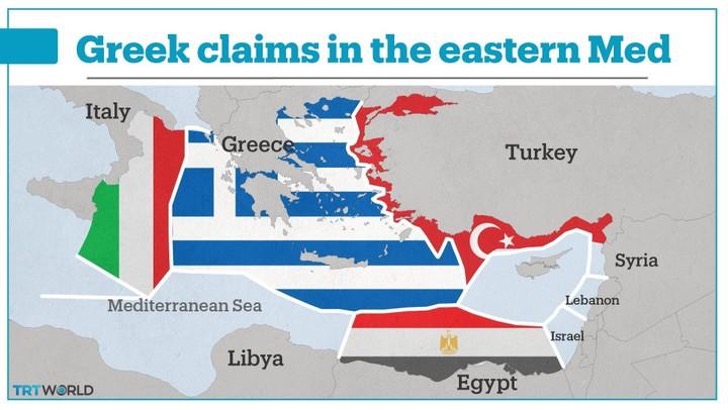
Figure 3:[72] If Türkiye did not assert its claim in the Eastern Mediterranean, this is what Greece’s EEZ would look like.
A clear result of these overlaps being unsolved was the 2019 Türkiye-Libya Memorandum of Understanding on maritime boundaries. Türkiye negotiated with Libya’s then UN-recognized government to draw an EEZ boundary across the Eastern Mediterranean between their two coasts. The line they drew effectively ignored the presence of any Greek islands (like Crete, Rhodes, Kastellorizo) between Türkiye and Libya – as if Türkiye and Libya were adjacent. This MoU angered Greece, which called it illegal and responded by quickly signing a nominal partial EEZ delimitation agreement with Egypt in 2020.
The development of a regional framework for energy cooperation, similar to arrangements in the North Sea or the Caspian Sea, could provide a pathway for resolving these disputes while enabling energy development to proceed.[73]
| Actor | Positions | Interests | Issues / Problems | Means of influence / power | Willingness to negotiate |
| Greece | Definition of sea borders in accordance with UNCLOS | Expansion of EEZ; Balancing against/ deterring Türkiye | Threat perceptions from Türkiye | EU membership; Regional alliances (Egypt, Israel) | Low |
| Türkiye | Rejection of UNCLOS; Recognition of TRNC’s EEZ | Exploitation of energy resources; Aspiration to become regional power and an energy hub; Protection of TRNC interests | Tensions with other regional states (e.g., Egypt, Israel); Exclusion from regional alliances such as EAST-MED | Military power; Regional alliances (Libya) | High (Low since 2019) |
| Greek Administration of Southern Cyprus (GASC) | GASA’s sea borders representing the island as a whole | Balancing against/ deterring Türkiye; Protection of sea borders | Insecurity emanating from Türkiye | EU membership; Regional alliances | Low |
| Turkish Republic of Northern Cyprus (TRNC) | Recognition of TRNC’s sea borders and EEZ | Full recognition of TRNC and sea borders | De facto status/ unrecognition | Turkish military power | High (Low since 2019) |
Table 1: Actors’ Positions, Interests, Issues, Means of Influence, and Willingness to Negotiate in the Eastern Mediterranean[74]
- South China Sea Arbitration (Philippines v China)
The South China Sea Arbitration between the Philippines and China, concluded in 2016, is a landmark case concerning EEZ delimitation and historic rights claims under UNCLOS. In 2013, the Philippines initiated arbitral proceedings against China under Annex VII of UNCLOS. The Philippines challenged the legality of China’s ‘nine-dash line’ claim, the legal status of various maritime features, and the lawfulness of China’s actions in the region.[75] China refused to participate stating that the tribunal lacked jurisdiction and that it would not accept the award.[76]
The Permanent Court of Arbitration ruled that China’s claim to historic rights within the “nine-dash line” had no legal basis under UNCLOS.[77] The Tribunal emphasized that UNCLOS provides a comprehensive framework for maritime zones and grants coastal states exclusive rights within their 200-nautical-mile EEZs, leaving no room for unrecognized historic claims.[78] This decision clarified that maritime entitlements must be determined objectively by international legal standards, not unilateral assertions. Globally, the ruling reinforces a rules-based approach to EEZ delimitation and limits the validity of expansive historic claims.[79] However, enforcement remains difficult, especially when smaller states challenge major powers like China, which continues to assert strategic control over the region despite the Tribunal’s findings.
Ⅴ. INTERIM SOLUTIONS FOR OFFSHORE ENERGY DEVELOPMENT
Overlapping EEZ claims may take years to resolve. So, in situations where immediate agreement on a boundary is impossible, international law encourages interim solutions that enable progress in resource exploitation without hurting the claims of the parties. The most common form of such interim solutions in terms of offshore energy is the Joint Development Zone (JDZ) – an agreed area where two (or more) states come together in order to explore and exploit resources.[80]
As the legal basis for JDZ, Article 74 (3) and Article 83 (3) of UNCLOS provide clear provision for coastal states to pursue any efforts in practical nature to cooperate with neighboring countries when no deal or consensus has been reached for maritime delimitation.[81] The arrangement must be held in the spirit of understanding and cooperation. No formal or standard forms specified by the articles. However, many countries use bilateral agreements or memorandum of understanding to achieve consensus on their points of intent. The disputed countries are prohibited to jeopardize or to hamper each other by taking actions that are harmful or deterring efforts to achieve final consensus or agreement on maritime delimitation in EEZ and also continental shelf.[82] Indeed, Articles 74(3) and 83(3) explicitly state that such arrangements “shall be without prejudice to the final delimitation”, meaning that by entering a JDZ a state does not concede its claim nor does the other state gain any legal advantage in a later delimitation. This is usually reinforced in the text of the JDZ agreement. For example, the 2001 Nigeria–São Tomé and Príncipe joint development treaty (for an overlapping offshore area in the Gulf of Guinea) contains a clause that nothing in the treaty shall be interpreted as a renunciation or recognition of claims by either side.[83] These articles encourage coastal states that have not been able to resolve their disputes to use convenient, flexible and conducive ways.
The advantage of JDZ is giving a practical way for countries to start using oil and gas resources without waiting for a final border agreement or decision. Instead of leaving valuable areas untouched or risking conflict from one side acting alone, both countries can benefit by sharing the resources. This not only brings in revenue and energy but also builds trust through cooperation between operating states and reduces the possibility of conflict in disputed areas.[84] It also helps avoid the usual fear that one country’s gain is the other’s loss—in JDZ both sides win. This is especially useful when it’s unclear exactly where the oil or gas is located.[85] Drawing a border too soon could accidentally place all the resources on one side.[86] Joint development skips the need for a boundary from the start, reducing the chance of disputes over who gets what and allowing countries to move forward without settling the tough sovereignty issues right away.[87] However, JDZ are often difficult to negotiate and implement due to the high level of political trust required, the administrative complexity of creating joint authorities that satisfy both parties’ legal and bureaucratic systems, concerns over imbalances in technical capacity that may leave one side feeling disadvantaged, and political risks such as encouraging excessive claims or creating the impression of accepting future boundaries.[88] Yet despite these challenges, JDZs can still serve as a fair and functional compromise in otherwise deadlocked situations.
Each JDZ is different, shaped by the needs and agreements of the countries involved, and because of these differences, several joint development models have emerged around the world.
| Model | Description | Example(s) |
| Zone-splitting model | The joint area is divided into sub-zones, each state manages operations in its own sub-zone, with some revenue sharing across zones. | Japan–South Korea Agreement (1974) |
| Joint authority model | A supranational joint authority (with representatives from both states) manages the entire zone and makes decisions together. Usually includes equal or agreed sharing of costs and production. | Timor Gap Treaty (Australia–Indonesia, 1989); Australia–Timor-Leste arrangements |
| Single operator model | One state (often with more technical capacity) leads resource development on behalf of both, and shares output or revenue based on agreed terms. | Iran–Qatar (South Pars/North Field); Timor Sea (Australia–Timor-Leste, post-conciliation arrangement) |
Table 2: Three most common JDZ models.[89]
Regardless of model, all JDZs require settling practical details: how to divide revenues, how to deal with taxation, which domestic law applies to operations and to workers, how to handle environmental regulation and liability, and what happens if a company straddles outside the zone.[90]
Other interim approaches also exist. States might agree on a moratorium on drilling in particularly sensitive or disputed areas while allowing exploration elsewhere or states can also conclude unitization agreements for known trans-boundary oil/gas fields in order to jointly manage a specific reservoir.[91] Anyway, the form of interim solution must suit the specific dispute, but the principle for establishing interim solutions is clear: positive obligation of conduct and a negative obligation of self-restraint.[92]
CONCLUSION
The EEZ has become a key feature of modern sea and maritime law, giving coastal states special rights to explore and manage resources up to 200 nautical miles from their shores. The EEZ framework was developed through the lengthy and complex UNCLOS III debates and was designed to find balance between coastal states and the international community.
Overlapping EEZ claims often result from nearby coastlines, disputes over whether islands generate full rights, and the desire to control offshore oil and gas. These issues were made worse by politics and old territorial claims. The 2016 South China Sea Arbitration was a turning point, rejecting broad historic claims and reinforcing UNCLOS as the legal standard for maritime rights. The Black Sea case stands out for its clear and structured use of the three-stage delimitation method, showing that judicial resolution can effectively address complex maritime disputes.
UNCLOS includes a solid dispute resolution system (Part XV), offering courts like ITLOS and the ICJ, along with arbitral tribunals, to help states settle disagreements. But their success depends on countries’ willingness to cooperate. In the meantime, many use JDZs as a temporary way to share resources without resolving boundaries, helping avoid conflict and keep development moving forward.
Still, enforcement can be challenging especially when powerful states ignore rulings. Domestic politics, growing geopolitical tension, and new deep-sea technologies add even more complexity. For the EEZ to remain effective, states must stay committed to cooperation, international law, and adapting legal tools to meet modern challenges.
[1] The EEZ is a concept formalised by the 1982 United Nations Convention on the Law of the Sea (UNCLOS), a landmark treaty often described as the ‘constitution for the oceans’. It grants coastal States sovereign rights over the natural resources in a vast area extending up to 200 nautical miles from their coastlines. This innovation was a significant achievement, placing approximately 85 per cent of commercially exploitable fish stocks and the majority of known offshore oil and gas reserves under national jurisdiction. For many developing nations, the EEZ represented a crucial tool for gaining control over resources that were previously exploited by distant-water fleets of more developed States; for further reading: Robert Beckman and Tara Davenport, Law of the Sea and the South China Sea (Edward Elgar Publishing 2022)
[2] Tim Martin, ‘Energy and International Boundaries’ in Tina Hunter (ed), Research Handbook on International Energy Law (Edward Elgar Publishing 2014)
[3] Clive Schofield, ‘Cooperative Mechanisms and Maritime Security in Areas of Overlapping Claims to Maritime Jurisdiction’ in Sam Bateman (ed), Maritime Security in Southeast Asia (RoutledgeCurzon 2005).
[4] The stakes are particularly high in regions like the Eastern Mediterranean, South China Sea, and Black Sea, where substantial energy discoveries have occurred in areas of overlapping maritime claims; for further reading: M Iglesias, ‘UNCLOS and Territorialization of the Seas: The Case of Indian and Pacific Oceans’ (2017) (9) Journal de Ciencias Sociales <https ://doi.org/10.18682/jcs.v0i9.659>.
[5] The origin of the concept of the EEZ may go back to the practice of the Latin American States after World War II. Originally the figure of 200 nautical miles appeared in 1947, when Chile, Peru and Ecuador claimed such an extent for the exercise of full sovereignty. In 1971, Kenya proposed the concept of the EEZ in the Asian-African Legal Consultative Committee at Colombo in a spirit of compromise. In August 1972, with overwhelming support from the developing countries, Kenya formally submitted its proposal for a 200-mile EEZ to the UN Seabed Committee. Further to this, a variant of the concept of the EEZ, the notion of the ‘patrimonial sea’, was reflected in the Declaration of Santo Domingo, adopted by the Conference of Caribbean Countries on 7 June 1972. On 2 August 1973, Colombia, Mexico and Venezuela submitted its proposal for the ‘patrimonial sea’ to the Seabed Committee.The two concepts effectively merged at UNCLOS III. By 1975, the basic concept of the EEZ seemed to be well established.13 Thus the legal regime governing the EEZ was embodied in Part V of the LOSC. for further reading: Y Tanaka, The International Law of the Sea (Cambridge University Press 2012) 158.
[6] Robin R Churchill, ‘The Impact of State Practice on the Jurisdictional Framework Contained in the LOS Convention’ in Stability and Change in the Law of the Sea: The Role of the LOS Convention (Brill | Nijhoff 2005) <https ://doi.org/10.1163/9789047416166_013> accessed 7 August 2025.
[7] RR Churchill and AV Lowe, The Law of the Sea (3rd edn, Manchester University Press 1999)
[8] Tanaka, 160
[9] United Nations Convention on the Law of the Sea (adopted 10 December 1982, entered into force 16 November 1994), arts 55, 57.
[10] UNCLOS, art. 56
[11] Spyridon Petros and Georgios Chrysochou, ‘SouthEastern Mediterranean: The Case-Study of Geopolitics and Maritime Delimitation Issues’ (2014) 5(13) International Journal of Business and Social Science http://ijbssnet.com/journals/Vol_5_No_13_1_November_2014/26.pdfaccessed 7 August 2025.
[12] Sovereignty in the territorial sea means the coastal state exercises full sovereignty over the waters, airspace, seabed, and subsoil—just like it does on land—but must allow innocent passage for foreign ships. See also: DP O’Connell, ‘The Juridical Nature of the Territorial Sea’ (1971) 45 The British Year Book of International Law 303.
[13] Nguyen LN, The Development of the Law of the Sea by UNCLOS Dispute Settlement Bodies (Cambridge University Press 2023).
[14] UNCLOS, art. 56(1)(b)
[15] UNCLOS, art. 58(1). See also Y Tanaka, The International Law of the Sea (Cambridge University Press 2012).
[16] Z Guobin, ‘A Discussion on Due Regard in the United Nations Convention on the Law of the Sea’ (2014) China Oceans Law Review 70 <https ://heinonline.org/HOL/LandingPage?handle=hein.journals/cholr2014&div=36&id=&page=> accessed 7 August 2025.
[17] Diarra MG, ‘Analysis of the Jurisprudence of Article 58 of the United Nations Convention on the Law of the Sea (UNCLOS) and the Positions of West African Countries’ (2024) 6(4) International Journal of Law and Politics Studies 75 https://doi.org/10.32996/ijlps.2024.6.4.8accessed 7 August 2025.
[18] Basir SM and Abd Aziz SN, ‘Undelimited Maritime Areas: Obligations of States Under Article 74(3) and 83(3) of UNCLOS’ (2020) 18(1) Indonesian Journal of International Law 41 https://scholarhub.ui.ac.id/ijil/vol18/iss1/3 accessed 7 August 2025.
[19]Ibid.
[20] Lilian Delabie, ‘The Role of Equity, Equitable Principles, and the Equitable Solution in Maritime Delimitation’ in Alex G Oude Elferink, Tore Henriksen and Signe V Busch (eds), Maritime Boundary Delimitation: The Case Law: Is It Consistent and Predictable? (Cambridge University Press 2018).
[21] David Anderson, ‘Maritime Delimitation in the Black Sea Case (Romania v. Ukraine)’ (2009) 8(3) The Law & Practice of International Courts and Tribunals 305 https://doi.org/10.1163/156918509X12537882648345 accessed 7 August 2025.
[22] Ibid.
[23] Ibid.
[24] Ibid.
[25] M Evans, ‘Relevant Circumstances’ in A G Oude Elferink, T Henriksen and S V Busch (eds), Maritime Boundary Delimitation: The Case Law: Is It Consistent and Predictable? (Cambridge University Press 2018) <https ://doi.org/10.1017/9781108344302.010> accessed 7 August 2025.
[26] J A Roach and R W Smith, ‘Exclusive Economic Zone’ (1994) 66(1) International Law Studies 11 <https ://digital-commons.usnwc.edu/cgi/viewcontent.cgi?article=1682&context=ils> accessed 7 August 2025.
[27] Dorinda G Dallmeyer and Louis De Vorsey (eds), Rights to Oceanic Resources: Deciding and Drawing Maritime Boundaries (Martinus Nijhoff Publishers 1989).
[28] Federal Republic of Germany v Denmark and the Netherlands (North Sea Continental Shelf cases) [1969] ICJ Rep 3, para 85.
[29] Ibid.
[30] Ibid.
[31] Tanaka, 263.
[32] UNCLOS, art.7
[33] Nicholas A Ioannides, Maritime Claims and Boundary Delimitation: Tensions and Trends in the Eastern Mediterranean Sea (Routledge 2020).
[34] Massimo Lando, Maritime Delimitation as a Judicial Process (vol 144, Cambridge University Press 2019).
[35] Ibid.
[36] Raul Curiel, ‘Overlapping Claims for an Extended Continental Shelf in the Northeastern Part of South America Facing the Atlantic Ocean’ (UN-Nippon Foundation Fellows Paper, 2010).
[37] UNCLOS, art. 76
[38] Yunus Emre Acikgonul and Edward R Lucas, ‘Developments in Maritime Delimitation Law over the Last Decade: Emerging Principles in Modern Case Law’ (2020) 57 Canadian Yearbook of International Law/Annuaire canadien de droit international 156 <https ://doi.org/10.1017/cyl.2020.9> accessed 7 August 2025.
[39] UNCLOS, art.121
[40]Iryna Varykasha, ‘Case Concerning Maritime Delimitation in the Black Sea (Romania v Ukraine). Investigation of Positions’ (2019) 19 Lex Portus 33 <https ://lexportus.net.ua/vipusk-5-2019/iryna_varykasha_case_concerning_maritime_delimitation_in_the_black_sea_romania_v_ukraine_investigation_of_positions.pdf> accessed 7 August 2025.
[41] Michael S Gau, ‘The Interpretation of Article 121(3) of UNCLOS by the Tribunal for the South China Sea Arbitration: A Critique’ (2019) 50(1) Ocean Development & International Law 49 https://doi.org/10.1080/00908320.2018.1511083 accessed 7 August 2025.
[42] Andreas Stergiou, ‘Türkiye–Cyprus–Israel relations and the Cyprus conflict’ (2016) 18(4) Journal of Balkan and Near Eastern Studies 375https://doi.org/10.1080/19448953.2016.1195994 accessed 7 August 2025.
[43]Ibid.
[44] Peter Dutton, ‘Three Disputes and Three Objectives: China and the South China Sea’ (2011) 64(4) Naval War College Review 42 <http ://www.jstor.org/stable/26397243> accessed 7 August 2025.
[45] Constantinos Yiallourides, ‘Joint Development of Seabed Resources in Areas of Overlapping Maritime Claims: An Analysis of Precedents in State Practice’ (2018) 31 USF Maritime Law Journal 129 <https ://heinonline.org/HOL/LandingPage?handle=hein.journals/usfm31&div=14&id=&page=> accessed 7 August 2025.
[46] Camille Goodman, ‘Compulsory Settlement of EEZ Fisheries Enforcement Disputes under UNCLOS: “Swallowing the Rule” or “Balancing the Equation”?’ (2023) 13 Goettingen Journal of International Law 27 <https ://heinonline.org/HOL/LandingPage?handle=hein.journals/gojil13&div=9&id=&page=> accessed 7 August 2025.
[47] M Rezaul Karim Chowdhury, Saharuddin Abdul Hamid and Nurul Haqimin Mohd Salleh, ‘Maritime Dispute Resolution: Understanding Adequacy of UNCLOS: A Systematic Review’ (2024) Australian Journal of Maritime and Ocean Affairs 1 <https ://doi.org/10.1080/18366503.2024.2416334> accessed 7 August 2025.
[48] UNCLOS, art. 281 and art. 282
[49] UNCLOS, art. 280 and art. 283
[50] The ICJ is the principal legal organ of the United Nations. Under Article 93 of the UN charter, all UN member states are Ipso Facto parties to the ICJ statute, but they are not required to submit any case to it except in case where they have consented or promised to do so. The ICJ only has jurisdiction to decide cases that states consent to submit to it for decision. The consent can take the form of binding treaties or declarations of varying scope. The Tribunal formed as per the Annex VI of the UNCLOS, ITLOS does not in principle, and have jurisdiction over a dispute unless both parties have agreed to it, by way of ad hoc declaration, special agreement or previous optional declaration. See also: Chowdhury, Hamid and Salleh, ‘Maritime Dispute Resolution: Understanding Adequacy of UNCLOS’ 4.
[51] UNCLOS, art. 286 and art.296
[52] UNCLOS, art. 287
[53] UNCLOS, art. 288
[54] UNCLOS, art. 290 and art. 292
[55] Goodman, ‘Compulsory Settlement of EEZ Fisheries Enforcement Disputes under UNCLOS’ 35.
[56] UNCLOS, art. 297
[57] UNCLOS, art. 298
[58] Goodman, ‘Compulsory Settlement of EEZ Fisheries Enforcement Disputes under UNCLOS’ 38.
[59] Chowdhury, Hamid and Salleh, ‘Maritime Dispute Resolution: Understanding Adequacy of UNCLOS’ 5.
[60] Maritime Delimitation in the Black Sea (Romania v Ukraine) [2009] ICJ Rep 61.
[61] Ibid.
[62] David J Bederman and Coalter G Lathrop, ‘Maritime Delimitation in the Black Sea (Romania v Ukraine)’ (2009) 103(3) American Journal of International Law 543 <https ://doi.org/10.2307/40283657> accessed 7 August 2025.
[63] Marcin Kaldunski, ‘Maritime Delimitation in the Black Sea: The Romania v Ukraine Case’ (2012) 1 Polish Review of International and European Law 109 <https ://heinonline.org/HOL/LandingPage?handle=hein.journals/polsvieu2&div=9&id=&page=> accessed 7 August 2025.
[64] Mehmet Efe Biresselioğlu, ‘Clashing Interests in the Eastern Mediterranean’ (2019) 21(4) Insight Turkey 115 <https ://www.jstor.org/stable/10.2307/26842781> accessed 7 August 2025.
[65] Thomas Alexandros Lolas, ‘The Cypriot EEZ: Challenges and Opportunities for the EU and Domestic Energy Policy’ (2023) <https://dione.lib.unipi.gr/xmlui/bitstream/handle/unipi/16065/The%20Cypriot%20EEZ.pdf?sequence=1> accessed 7 August 2025.
[66]Biresselioğlu, ‘Clashing Interests in the Eastern Mediterranean’ 122.
[67] Sertaç Hami Başeren, ‘Root Causes of the Eastern Mediterranean Dispute’ (2021) 23(1) Insight Turkey 11 <https://www.jstor.org/stable/10.2307/26989813> accessed 7 August 2025.
[68] Ibid.
[69] Ibid.
[70] Bora Sungur, ‘Legal Norms and Political Interests: A Study on the Maritime Jurisdiction Dispute in the Eastern Mediterranean’ (2024) <https ://arno.uvt.nl/show.cgi?fid=180064> accessed 7 August 2025.
[71]Emete Gözügüzelli, ‘International Law of the Sea and Megisti’ (2021) 4(1) Türkiye Siyaset Bilimi Dergisi 39 <https ://dergipark.org.tr/en/download/article-file/1658677> accessed 7 August 2025.
[72] ‘Türkiye-Greece Tensions: Eastern Mediterranean Claims in Maps’ TRT World (1 September 2020)https://trt.global/world/article/12756451 accessed 7 August 2025.
[73]Moritz Rau, Günter Seufert and Kirsten Westphal, The Eastern Mediterranean as a Focus for the EU’s Energy Transition: Deep-Rooted Enmities and New Opportunities for Cooperation between Greece, Turkey and Cyprus (SWP Comment No 8/2022, 2022) <https ://doi.org/10.18449/2022C08> accessed 7 August 2025.
[74]Esra Dilek, ‘Sovereignty Disputes and Resource Discoveries in the Eastern Mediterranean: A Conflict Analysis Perspective’ (2022) 1(2) Journal of Middle East Perspectives 133 <https://dergipark.org.tr/en/download/article-file/2950173> accessed 7 August 2025.
[75] The South China Sea Arbitration (Philippines v China) (2016) 33 RIAA 153.
[76] Michael D Swaine, ‘Chinese Views on the South China Sea Arbitration Case between the People’s Republic of China and the Philippines’ (2016) 51(1) China Leadership Monitor 1 <https://carnegie-production-assets.s3.amazonaws.com/static/files/CLM51MS.pdf> accessed 7 August 2025.
[77] The South China Sea Arbitration (Philippines v China) (2016) 33 RIAA 153.
[78] Ibid.
[79] Vincent P Cogliati-Bantz, ‘The South China Sea Arbitration (The Republic of the Philippines v The People’s Republic of China)’ (2016) 31(4) The International Journal of Marine and Coastal Law 759 <https://doi.org/10.1163/15718085-12341421> accessed 7 August 2025.
[80] Yusuf considers that joint development ‘is a type of legal arrangement that allows two or more coastal neighbors to conduct the joint exploration and production of petroleum resources situated in areas of overlapping claims. Emmers describes joint development as an agreement between two or more states ‘whereby they pool their sovereign rights for the exploration and exploitation of natural resources and other purposes in a defined maritime area’. He further adds that ‘they are meant to temporarily set aside boundary negotiations so that the joint development of natural resources might proceed on an agreed basis within a specific period of time.’ Blyschak defines joint development in a strict sense, as ‘a procedure under which boundary disputes are set aside, without prejudice to the validity of the conflicting claims, and the interested states agree, instead, to jointly explore and exploit and to share any hydrocarbons found in the area subject to overlapping claims’. Miyoshi views joint development more broadly as ‘an inter-governmental arrangement of a provisional nature, designed for functional purposes of joint exploration for and/or exploitation of hydrocarbon resources of the seabed beyond -the territorial sea’. For further reading: Yiallourides, ‘Joint Development of Seabed Resources’ 131.
[81] The former article regulates arrangement for disputes in EEZ, while the latter one sets it for disputes in the continental shelf. See also: Mohammad Faiz Aziz, ‘Developing Joint Development Zone in Disputed Maritime Boundaries’ (2017) 15 Indonesian Journal of International Law 432 <https ://heinonline.org/HOL/LandingPage?handle=hein.journals/indjil15&div=25&id=&page=> accessed 7 August 2025.
[82] Ibid.
[83]E L Wifa, M Amakoromo and I Johnson Ogbo, ‘The Role of a Joint Development Agreement (JDA) in Resolving the Conflicts and Uncertainties over Maritime Boundary Delimitation: A Missed Opportunity in the Bakassi Case’ in EEU Enyioko, OSA Obasanjo-Sampson and A Berhe (eds), The Bakassi Dispute and the International Court of Justice: Continuing Challenges (Routledge 2017).
[84] Clive Schofield, ‘Cooperative Mechanisms and Maritime Security in Areas of Overlapping Claims to Maritime Jurisdiction’ (2005) <https ://ro.uow.edu.au/lawpapers/261> accessed 7 August 2025.
[85] Masahiro Miyoshi, The Joint Development of Offshore Oil and Gas in Relation to Maritime Boundary Delimitation (IBRU Maritime Briefing Vol 2 No 5, IBRU Press 1999).
[86] Ibid.
[87] Ibid.
[88] Schofield, ‘Cooperative Mechanisms and Maritime Security in Areas of Overlapping Claims’ 106.
[89] Çağatay Doğan, ‘Effects of Overlapping Maritime Zone Claims over the Offshore Oil and Gas Law: The Joint Development Agreements’ (2020) 2 City Law Review 260 <https://heinonline.org/HOL/LandingPage?handle=hein.journals/ctylwrvw2&div=28&id=&page=> accessed 7 August 2025.
[90] Over the past few decades, several successful JDZs have been implemented: for instance, the Malaysia–Thailand Joint Development Area in the Gulf of Thailand (agreed 1979, operational since 1990), which shares gas production equally; the Nigeria–São Tomé and Príncipe JDZ (2001) with a 60:40 split of revenue; the Japan–Korea agreement over a portion of continental shelf (1974); the France–Spain agreement in the Bay of Biscay (1974) for an area pending delimitation (though later they finalized a boundary); and more recently, provisional arrangements like Australia and Timor-Leste’s 2018 Treaty, which, while establishing a permanent boundary, also provides for a continued sharing of the Greater Sunrise gas field revenues (70% to Timor-Leste) – effectively a joint development of that trans-boundary resource.
[91] Ramy E Murr, ‘Interim Solutions Under the Exclusive Economic Zone Regime: New Analyses and Prospects’ (2022) 18(1) Maritime Affairs: Journal of the National Maritime Foundation of India 12.
[92] Positive obligation of conduct means that States ‘shall make every effort to enter into provisional arrangements of a practical nature’. This requires them to engage in good faith negotiations with a view to establishing a cooperative framework pending a final settlement. Negative obligation of self-restraint means that during this transitional period, States must ‘not to jeopardize or hamper the reaching of the final agreement’. See also: Salawati Mat Basir and Saidatul Nadia Abd Aziz, ‘Undelimited Maritime Areas: Obligations of States Under Article 74(3) and 83(3) of UNCLOS’ (2020) 18(1) Indonesian Journal of International Law 41.